After yesterday's hike of Algonquin with Andy and Gordon, we (Rick & Mike) decided to take another crack at taking in some High Peaks views by hiking Hurricane Mountain. Once again, Teena and Elizabeth hung out in Lake Placid with Gordon, Andy, and Sue (and Andy Jr.). Teena plans to test her hiking feet in October.
After a 1.5 hour hike up, Rick & Mike reached the summit. The weather started out chilly and windy with beautiful sunny skies. However, by the time the summit was reached, a new blanket of clouds arrived and shrouded the summits of the tallest mountains.
The hike started out with an immediate steep pitch. The pitch remained relatively steep for the first 1/4 - 1/2 mile. After that, the hike was relatively flat for about 1+ miles. Through this flat section, we crossed several bog-like fields, and one evergreen "tunnel."
One thing that stands out about this hike is that we were the first ones to the trail head. We started hiking around 8:30am. As a result, we had the distinct privilege of eliminating all the spider webs. Yuck! Neither of us could believe the sheer volume of webs we took out. (My skin itches everywhere as I write this!) Luckily, neither of us is really bothered by spiders or their webs.
Eventually, the level trail gave way to a steep ascent. The trail was pretty much uphill most of the way from this point to the summit, with a few sections that were very steep. Near the top, we had to "button-hook" right to get to the large rock formations that lead to the summit.
We were told that Hurricane Mountain was once used to conduct geological surveys of the surrounding region. NO Wonder!!! The summit has awesome 360 degree views, and the hike up was pretty quick. Cascade, Big Slide, Algonquin, Colden, and Marcy (as well as all the other peaks in-between were visible to the west. To the North, Whiteface. To the East, the Green Mountains and Lake Champlain were easily in sight. What was really cool about the eastern view was that Vermont's Mount Mansfield and Camel's Hump Mountain were plainly visible before the cloud formations obstructed them. To the south, "back" side of Giant, Rocky Peak, Bald Mountain, Noonmark, Bear's Den, and the Great Range were visible.
Our views were somewhat mixed because of the extensive cloud cover, but they were far superior to the views we had from Algonquin the day before! In many ways, we liked this because the clouds add a certain "character" to the mountainous scenery.
When we tried to climb the fire tower at the summit, we found it to be in a state of disrepair. If you look at the pictures closely enough, you'll see that the ladder rungs have been removed to prevent people from climbing it. This tower is listed as an "endangered tower" on page 18 of the September/October 2001 issue of Adirondac magazine. According to the article, it is a "non-conforming" tower that was slated to be removed in August 2001. We're glad we got the opportunity to see it before it gets taken away.
We hung out at the summit for about an hour to eat some lunch, scope out the surrounding mountains, and chat with a fellow hiker named Kathy. We departed from the summit around 11:30 so we could meet up with Teena Baby Elizabeth, and begin the long ride home.What will we remember from this trip? A "nice" quick hike up and down. Spectacular views. The fire tower - a first for each of us - with its ladder rungs ripped out.
For more information on Hurricane Mountain, click here to visit the Adirondack Mountain Club (ADK) writeup, or here to visit a nice winter report at a "Towns and Trails" site.
STATS SUMMARY:
Date of Summit: 09/23/2001
Team: Mike Bowen, Rick Allen
Location: Adirondack High Peaks (44.214694,-73.840485)
Summit Elevation: 3,694'
Vertical Ascent: ~1,982'
Approach: South Trail from Rt. 9N
Trailhead to Summit: ~2.6 miles
Time to summit: ~90 minutes
Weather: Sunny at first, then overcast. Chilly, with temps in the fifties
Trail Difficulty: Moderate - sustained steep sections at the start and summit, with relatively easy hiking in between.
Photo Album: (10 pictures) Click on picture to see a larger version.

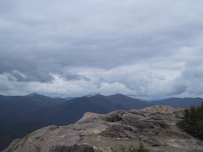


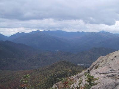


Photo Album: (10 pictures) Click on picture to see a larger version.

Rick points to the approaching clouds and offers his sandwich as an offering for clear skies.

Looking west, Algonquin is shrouded in clouds.

"High" Peaks, from left to right: Giant Mountain, Bald Mountain, Noonmark Mountain, Bear's Den Mountain, and the Ausable Lake valley.

Rocky Ridge Peak and Giant Mountain. That's "Green Mountain" in the foreground - not to be mistaken for Vermont's Green Mountains.

The "Great Range" of the High Peaks is in the background. Lower Wolf Jaw, Upper Wolf Jaw, Armstrong, Gothics, Saddleback, and Marcy. Colden is farthest to the right.

Rick & Mike pose in front of Hurricane's fire tower. Notice the missing ladders at the lower levels.

Meanwhile... Mike decides that his climbing exploits for the day aren't finished yet. "Missing ladder rungs are no obstacle!"

...Here's the "Farscape" shot. It's too bad that this tower is "non-conforming." The debate as to how strict New York's "Forever Wild" clause should be enforced is an interesting one.

Rick squares off against intrepid explorer Kathy. It looks like a great struggle is about to ensue... Neither one giving an inch.

The stalemate is broken by Rick's clever wit, and by the "cameraman" shouting "Hey! Look into the camera!"
No comments:
Post a Comment