Sunday, September 23, 2001

Hurricane Mountain

Trip Report:  Great Views Atop Hurricane Mountain
After yesterday's hike of Algonquin with Andy and Gordon, we (Rick & Mike) decided to take another crack at taking in some High Peaks views by hiking Hurricane Mountain.  Once again, Teena and Elizabeth hung out in Lake Placid with Gordon, Andy, and Sue (and Andy Jr.).  Teena plans to test her hiking feet in October.
After a 1.5 hour hike up, Rick & Mike reached the summit.  The weather started out chilly and windy with beautiful sunny skies.  However, by the time the summit was reached, a new blanket of clouds arrived and shrouded the summits of the tallest mountains. 
The hike started out with an immediate steep pitch.  The pitch remained relatively steep for the first 1/4 - 1/2 mile.  After that, the hike was relatively flat for about 1+ miles.   Through this flat section, we crossed several bog-like fields, and one evergreen "tunnel."
One thing that stands out about this hike is that we were the first ones to the trail head.  We started hiking around 8:30am.  As a result, we had the distinct privilege of eliminating all the spider webs.  Yuck!  Neither of us could believe the sheer volume of webs we took out.  (My skin itches everywhere as I write this!)  Luckily, neither of us is really bothered by spiders or their webs.
 Eventually, the level trail gave way to a steep ascent.  The trail was pretty much uphill most of the way from this point to the summit, with a few sections that were very steep.  Near the top, we had to "button-hook" right to get to the large rock formations that lead to the summit.
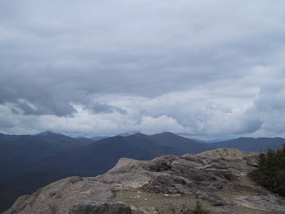
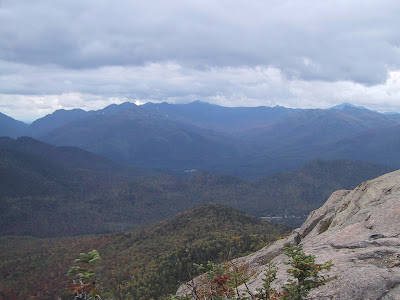
We were told that Hurricane Mountain was once used to conduct geological surveys of the surrounding region.  NO Wonder!!!  The summit has awesome 360 degree views, and the hike up was pretty quick.  Cascade, Big Slide, Algonquin, Colden, and Marcy (as well as all the other peaks in-between were visible to the west.  To the North, Whiteface.  To the East, the Green Mountains and Lake Champlain were easily in sight.  What was really cool about the eastern view was that Vermont's Mount Mansfield and Camel's Hump Mountain were plainly visible before the cloud formations obstructed them.  To the south, "back" side of Giant, Rocky Peak, Bald Mountain, Noonmark, Bear's Den, and the Great Range were visible.
Our views were somewhat mixed because of the extensive cloud cover, but they were far superior to the views we had from Algonquin the day before!  In many ways, we liked this because the clouds add a certain "character" to the mountainous scenery.
When we tried to climb the fire tower at the summit, we found it to be in a state of disrepair.  If you look at the pictures closely enough, you'll see that the ladder rungs have been removed to prevent people from climbing it.  This tower is listed as an "endangered tower" on page 18 of the September/October 2001 issue of Adirondac magazine.  According to the article, it is a "non-conforming" tower that was slated to be removed in August 2001.  We're glad we got the opportunity to see it before it gets taken away.
We hung out at the summit for about an hour to eat some lunch, scope out the surrounding mountains, and chat with a fellow hiker named Kathy.  We departed from the summit around 11:30 so we could meet up with Teena Baby Elizabeth, and begin the long ride home.
What will we remember from this trip?  A "nice" quick hike up and down.  Spectacular views.  The fire tower - a first for each of us - with its ladder rungs ripped out.
For more information on Hurricane Mountain, click here to visit the Adirondack Mountain Club (ADK) writeup, or here to visit a nice winter report at a "Towns and Trails" site.

STATS SUMMARY:
Date of Summit: 09/23/2001
Team:  Mike Bowen, Rick Allen
Location:  Adirondack High Peaks (44.214694,-73.840485)
Summit Elevation:  3,694'
Vertical Ascent:  ~1,982'
Approach: South Trail from Rt. 9N
Trailhead to Summit: ~2.6 miles
Time to summit:  ~90 minutes
Weather:  Sunny at first, then overcast.  Chilly, with temps in the fifties
Trail Difficulty:  Moderate - sustained steep sections at the start and summit, with relatively easy hiking in between.

Photo Album:  (10 pictures)  Click on picture to see a larger version.

Rick points to the approaching clouds and offers his sandwich as an offering for clear skies.

Looking west, Algonquin is shrouded in clouds.

"High" Peaks, from left to right: Giant Mountain, Bald Mountain, Noonmark Mountain, Bear's Den Mountain, and the Ausable Lake valley.

Rocky Ridge Peak and Giant Mountain.  That's "Green Mountain" in the foreground - not to be mistaken for Vermont's Green Mountains.

The "Great Range" of the High Peaks is in the background.  Lower Wolf Jaw, Upper Wolf Jaw, Armstrong, Gothics, Saddleback, and Marcy.  Colden is farthest to the right.

Rick & Mike pose in front of Hurricane's fire tower.  Notice the missing ladders at the lower levels.

Meanwhile...  Mike decides that his climbing exploits for the day aren't finished yet.  "Missing ladder rungs are no obstacle!"


...Here's the "Farscape" shot.  It's too bad that this tower is "non-conforming."  The debate as to how strict New York's  "Forever Wild" clause should be enforced is an interesting one.

Rick squares off against intrepid explorer Kathy.  It looks like a great struggle is about to ensue...  Neither one giving an inch.

The stalemate is broken by Rick's clever wit, and by the "cameraman" shouting "Hey!  Look into the camera!"

Saturday, September 22, 2001

Algonquin

Trip Report:  Los Amigos Tackle Mighty Algonquin!

SUMMARY:
Teena, Elizabeth, and I visited Lake Placid for the second time in three weeks to meet up with our friends Rick, Gordon, Andy, and Sue.  "Los Amigos" planned to hike Algonquin and Iroquois on Saturday while the ladies shopped, toured, etc...  Teena, still recovering from a July delivery of Baby Elizabeth, plans to make her big hiking comeback debut in October 2001.

After a rough start, three of "Los Amigos" successfully ascended Algonquin Mountain (Andy, Mike, and Rick), reaching the cloud-shrouded summit at about 11:30am.  Gordon reached to within a few hundred feet of the summit before being turned back by the generally inclement weather - a fact that we will constantly remind him of.  Unfortunately, the cloud cover never dissipated, meaning that Andy and Gordon had to apply their imaginations in new and creative ways to see the surrounding scenes.

Because of the lack of views, the very high winds, and because Mike knows he'll be back on Algonquin again someday, the ascent of Iroquois Peak was abandoned.

We arrived back at the Loj trail head around 4:15pm, making much better time on the way down than we did on the way up.  We regrouped in Lake Placid for dinner at 7:00pm at the Lake Placid Brew Pub.  There, Rick and Mike discussed plans to hike up Hurricane Mountain the next day (click here for that report).

This was Mike's 2nd successful ascent of Algonquin.

DETAILS:

Teena and I headed to Lake Placid for the second time this month.  The first trip resulted in a Phelps Trip Report and a 1st Adirondack trip for young Baby Elizabeth.  This time, instead of checking into the trusted Woodlake Motor Lodge, we decided to stay at Placid Bay Inn.  Earlier this month, we learned that travel with a baby requires additional space.  Placid Bay offered a room with a king size bed, kitchenette, and walk-in closet for ~$75.

It was a cold, wet start as we arrived at the Loj trail head and started hiking at 7:25am.  Yet another major weather system went through the area overnight, unloading an extensive payload of rain on the area.  Even as Rick picked us up at 6:30am, the rain was still pouring.  The weather was a about 50 degrees, drizzly, and overcast when we started hiking.  Like the Phelps hike a few weeks before, this wasn't exactly the type of weather you want for taking some friends on their first High Peaks hiking trip.

Each hiking trip has its own interesting side story...  That story for this trip belongs to Rick.  He started the trip quite "ill,"  fertilizing the local plant life with plenty of oats.  The cause of this sudden illness - seedy, bottom of the barrel "Ubu Ale" at the Down Hill Grill, or the "love fest" in the room above him at the St. Moritz - remains unknown.  Lucky for all of us, the Ale worked it's way out of his system, his lack of sleep energized him, and his terrifying memories of "squeaking" the night before provided plenty of jokes and tall tales throughout the hike!  At the end of the day, Rick was arguably better off than any of us!

This first mile of the 4.2 mile ascent took us only 20 minutes, after which we stopped for a quick breather and posed for pictures at the trail junction for Marcy Dam.  Somewhere in our conversations at this point, the following exchange took place:  "How far is it to the summit, Mike?"  "About 4+ miles."  "Great...  We should be there in an hour then."  "Uh huh...  Hold on to that spirit........"  Within the first 1/4 mile, the drizzle stopped, and we were able to put away our jackets.

After the next 1/2 mile and another 20 minutes (notice the diminishing return on time?), we arrived at the Whale's Tail ski trail to Wright's summit.  We stared for a few moments and wondered aloud at how hard it must be to ski uphill at such a pitch.  We then hiked and rested on and off for another mile, and another hour (what happened to 20 minutes per mile rule?), hitting some increasingly steeper terrain, until we reached a beautiful waterfall.  There, we stopped for 20+ minutes to climb the falls and take pictures.  Once we got started again, we hiked for another 1/2 mile to the trail junction for the summit of Wright Peak.  Shortly into that 1/2 mile, Gordon began to fall behind, and requested that the rest of us continue up - he would meet us at the summit.

"Remember I told you that this gets steep?" Mike chuckled...  The next 1/2 mile or so to the tree line was extremely steep, but took little time to traverse as we "bulled" our way through it.  Once above the tree line, we were greeted by extreme winds and powerful gusts.  Above our heads, the canopy of clouds could almost be reached.  At this point, we could still see the summit of Wright peak, and much of the northern regions behind us.  But within a few minutes, we were in the clouds for good.

At the summit, we were kept company by constant 40mph winds, with gusts that were probably close to 60mph.  One of those gusts nearly knocked Rick cleanly off the summit in his eagerness to get there.  Rick, Andy, and Mike hung out at the summit for ~45 minutes, waiting for Gordon and thinking about whether or not to hike Iroquois.  In the end, we decided against hiking to Iroquois because we had no views, and the weather appeared to be getting worse.  Besides, we routinely saw blue skies above us, leading Mike to exclaim that there was a possibility to have "undercast" skies similar to those he experienced in January's ascent of Wright peak.

The weather began worsen with the arrival of increased winds and colder temps.  As we began our descent, we began asking fellow hikers if they had seen our friend, Gordon.  Surprisingly, about 1/2 said he was way back on the trail - behind the Wright Trail junction.  The other 1/2 said he was only a couple hundred feet away.  The latter proved true as we met up with Gordon less than 5 minutes from the summit.  Due to the lack of views, Gordon decided he'd rather turn around and head back to the trailhead instead of hiking to the summit.  In spite of the heckling and jabs we gave him on the way down, it's worth noting that intelligent people turn around before they've gone too far.  We posed for a couple group photos and headed back.

The hike down was uneventful and quick.  We stopped by the High Peaks Information Center for a quick break and some coffee.  Then we went back to Lake Placid, hit the Placid Brew Pub for dinner, and told tall tales to our friends and significant others.

What will we remember from this trip?  Yet ANOTHER "white out" atop a High Peak, this time being on top of Algonquin!  Andy's and Gordon's first High Peaks hiking adventure.  50mph+ gales on top of Algonquin!   ...And of course, Rick's adventurous start of the day!


STATS SUMMARY:
Date of Summit: 09/22/2001
Team:  Mike, Rick A., Gordon P., Andy Z.
Location:  Adirondack High Peaks (44.143664, -73.986536)
Summit Elevation:  5,114'
Vertical Ascent:  2,936'
Approach: ADK Loj parking lot
Trailhead to Summit: 4.8 miles
Time to summit:  ~4.5 hours
Weather:  Sunny, and HOT enough to melt rock!!!  91 degrees!!!  The heat index was over 100 degrees!!!
Trail Difficulty:  Difficult with steep terrain for the last mile of the hike to the summit.


Photo Album:


One mile into the trip...  Only 20 minutes?  4.2 miles to the summit?  We'll be home in time for lunch!!! 

The Whale's Tail ski trail junction...  "People actually ski UP  that?"  Mike explains the concept of "skins." 

Mike stands near the top of the waterfall.  In January 2001, he passed this same waterfall during his ascent of Wright Peak (click here for trip report, and click here for picture).

...Mike and Gordo pose in front of the waterfall. 


Andy also posed...   What can you say...   It's a nice shot!


Think Algonquin's last mile isn't steep?  Here, mighty mighty Rick clings onto life after a near fatal misstep.

¡Los Tres Amigos!  Andy, Rick, and Mike pose atop the shrouded peak of Algonquin, awaiting their compadre, Gordon.

Meanwhile...  "Indiana" Mike always says that being on top of a mountain must be what heaven is like.  (Nice leg-warmers!)

...Amidst the clouds that shroud Algonquin, it looks like he may have found it!

Although Andy's not too sure that there are actually views from up here, he still gives the thumbs up.  for the trip.

30 minutes:  Where's Gordon?  Los Tres Amigos begin to ask fellow travelers, "Have you seen a bald guy in a green shirt?"

One last group pose atop 'ol Algonquin...  Should we go to Iroquois?

Iroquois!  I can't even see the camera man!  Besides...  Where's Gordo?


It's amazing what one sees when approaching the summit!

Just below the summit, Los Tres Amigos regroup with Gordon in the place described by several hikers.

We all pose before heading back down to the parking lot.

 GR-R-R-R-R-R-UNT!!!
Rick explains, while flexing his muscles, that hiking Algonquin requires a strong will, and an even stronger physique.

"We were right here!"
Gordon pauses while on Loj Road to squash all the little people still atop of Algonquin.

Though not yet old enough to hike the Adirondack High Peaks, Baby Elizabeth dreams of the day she can join her parents, after studying the trail descriptions over dinner.

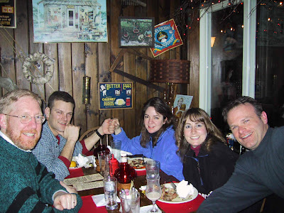
'Tis the end of the day...  The hiking party successfully regroups with Sue, Teena, and Baby Elizabeth at the Lake Placid Brew Pub.  Though we gave it our best shot, there was still plenty of Ubu Ale left in the keg by the end of the night!

Saturday, September 1, 2001

Phelps in the Rain

Trip ReportWhiteout atop Phelps

Dates:            September 1, 2001

Location:       Adirondack High Peaks

Team:           Mike and Scot

Destination:  Phelps Mountain Peak (4,161')

Approach:     ADK Loj parking lot

Author:          Mike


Summary:

Once again, Teena & I checked into the trusted Woodlake Motor Lodge on Saranac Avenue in Lake Placid on Friday night.  This time we were accompanied by our friends Scot & Cat, Michaela, and our six-week-old daughter, Elizabeth.  Scot & I intended to climb Phelps Mountain and eat lunch while viewing Marcy from one of the rocky outcroppings at the summit.  Teena, Cat, Michaela, and Elizabeth planned to spend the day shopping (OUCH!) in Lake Placid.  Teena plans to be back on the trails for a potential hike in October!!!Our plans were mostly fulfilled.  We reached the summit around 11:00am amidst the constant rain and overcast skies.  These conditions somewhat inhibited our summit views of Marcy and the surrounding area, and forced us to retreat into the trees to eat our lunches.  In the end, as the sun finally burned through the clouds as we arrived at our car, we claimed success at climbing Phelps, and providing Scot with his very first Adirondack High Peak hiking adventures.  
Details:

It was a cold damp morning start as we arrived at the Loj trail head and started hiking at 7:25am.  The weather was a cold 50+ degrees, drizzly, and overcast.  Not the type of weather you want for taking someone on their first hiking trip.  The parking lot at the ADK Loj was already quite full from cars left by backpackers - a sure sign that this must be the Labor Day weekend.  A major weather system moved through the area the previous night, supplying many hours of severe thunderstorms.  I imagined that there were many flooded tents. The hike was pretty standard, arriving at the Marcy Dam area a little before 9:00am.    We quickly crossed the "High Water Crossing" bridge at Phelps Brook and then took a break at the normal "low water crossing" site to pump water.  The water levels were surprisingly low, considering the amount of rain that hit the region over the past day.  We hit the trail again and reached the summit around 10:30am.  This pace was good since Scot wanted to be back in Lake Placid by mid-afternoon to join the rest of our troop.
The summit, as you might expect from the weather description, was shrouded in clouds, making for a wet experience.  Add a few 25mph wind gusts, and you get an idea of how cold it was.  The summit is mostly treed, and we followed several herd paths through the woods to find the U.S. Geological Survey marker that provides the highest elevation point.  Although we couldn't find the marker (maybe there isn't one?), we did find both rock outcrops that are reported to be at the top of Phelps.  We took turns taking pictures in the numbing air before evacuating the summit for warmer terrain and lunch!  
We hiked for about 15 minutes off the summit before breaking for lunch.  At this point, we shed out wet clothes for the dry ones in our packs.  A note to anyone hiking in wet weather...  I wore a "rain resistant" parka (REI rain resistant treatment) that was supposed to prevent water from penetrating it.  I found that the water pooled on the jacket instead, and leaked through precipitously.  I was wet, cold, and miserable.  I left my Gore Tex jacket at home since it was "too heavy" to wear.  Since this is the 2nd time I've had this luck with this technology and drizzle (the first time, I wore a similar EMS parka), I'm of the opinion that the only good rain protection is probably the Gore Tex.  I'm probably lucky that the air temperature wasn't very cold.
The trip back to the Loj parking lot was as fast-paced as the trip up had been.  In a moment of true back country gratis, we assisted a large crowd of about 20+ children cross Phelps Brook at the regular "low water" crossing.  For adults, this crossing was slippery but relatively easy.  For the 12 and under crowd?  The rushing white-capped rapids and distantly-spaced rocks provided a daunting obstacle.  Scot assumed "landing position" to help the children cross the rocks by providing them a steady hand.  I assumed the "Catcher-in-the-Rye" position, ready to catch any little travelers that might fall, or slip.  Luckily, with Scot's assistance, everyone successfully hopped across the stream without a single slip, and I wasn't called upon for any rescue attempts. 
The rest of the hike was pretty straight forward.  We arrived back at the Loj parking lot around 1:30pm.  Shortly afterward, the sun appeared and the clouds began to dissipate.  The temperatures soared.  "Should we go back up there now that we can see stuff?" I asked as we drank coffee in the High Peaks Information Center.  We both agreed that we'll save it for another day.  Instead, we talked with the rangers about the increased aggressiveness of the local black bear population, drove back to Lake Placid, and joined our companions for lunch at the Steak & Seafood restaurant.

What will we remember from this trip?  The "white out" atop of Phelps Mountain.  Mike's first taste of the "Adirondack Chill!"  Assisting the troop of young hikers cross Phelps Brook.


Pictures:
TBD - Converting all the old trip reports into this blog. 

Saturday, April 7, 2001

Tabletop has GREAT views!!!

Trip Report:  Good Views from Table Top?!?  

Dates:            April 7, 2001

Location:       Adirondack High Peaks

Team:           Mike & Joe

Destination:  Table Top Peak (4,427')

Approach:     ADK Loj parking lot

Author:          Mike

Summary:

Once again, we checked into the trusted Woodlake Motor Lodge on Saranac Avenue in Lake Placid on Friday night.  Our intended excursion was to hike to Indian Falls, and then decide whether to hike Marcy (5,344'), Table Top (4,427'), Phelps (4,161'), or back to the car.  Once we hit the trail, we were greeted by snow of immense proportions.  We were stunned by it.  We hiked Wright Peak only 9 weeks ago (click here for that trip report), and the snow level at that point was relatively low.  Even the High Peaks Information Center was pretty buried!  (See picture here.)   Donning our snowshoes, we hiked to Indian Falls, and then decided to climb Table Top.  Why?  For anyone that knows the High Peaks, Table top has terrible views, has a swampy summit, and requires a bushwhack to reach the top.  So our rationale went...  "When else can we reach the summit without mucking through mud, roots, etc, and also have the potential for some nice views?"  For once, our logic prevailed, the views were tremendous, and the climb was exhilarating.  We had some great tales to tell once we hit the Pub in Lake Placid.
Details:

It was a cold damp morning start as we arrived at the Loj trail head and started hiking around 7:00am.  As in our January trip, the sun was hiding, but at least there was no wind!  Even though the snow levels were unbelievable, we left our snowshoes strapped to our backpacks, believing that there had been enough traffic to pack snow on the start of the trail.  At the trail junction for Marcy Dam & Algonquin, we put on the snowshoes and scrambled out to Marcy Dam.
As you might expect for 7:00am in a snow-covered wilderness area the week before Easter, we saw few people.  We didn't see any wild life either, but that's probably because the "KLACK-KLACK-KLACK" noise of our snowshoes probably scared everything away (or at least it gave us headaches).  We reached Indian Falls at 10:00am.  To our pleasant surprise, the clouds gave way to a brilliantly sunny day.  The tops of Marcy, Colden, Algonquin could be seen to the south.  Phelps, and Table Top could be seen through the leave-less trees.  "What should we hike?" became the big question.  The decision process, though not very sophisticated, was effective:

Joe:    "So what do you want to do Mike?"

Mike:  "The views from Marcy are probably awesome!"

Joe:    "Table Top may be the same."

Mike: [stunned]  "Table Top?!?"
Both look up at Table Top's north face...

Mike:  "It does look pretty open up there..."
Joe:    "When will it have better views?"
Mike:  "Views?  On Table Top?"
Joe:    "Dunno..."
Mike:  "Wanna' try it?"
Joe:    "Sure!"
Mike:  "Let's go for it!"
The hike up Table Top, though only about a mile, took 1.5 hours.  We found a "broken" trail (and I use that term loosely) that was made by a single person a day or two before.  It went practically straight up to the peak through some pretty thick (but frozen) brush.  Oh...  We pretty much broke trail the whole way too.  Thanks to the deep snow, our heads were well into the canopy of tree branches.  At the summit, the snow was so deep that the tree tops were at our knees.  Spectacular views of Gothics and the Great Range were to the East.  The summits of Phelps, Basin, Haystack, Marcy, Colden, & Algonquin were all clearly visible.  To tell you the truth, this was absolutely one of the better views we've seen of the High Peaks.  It's the only vantage point from where I could see the Great Range, all of the Marcy-Colden-Algonquin ranges, Marcy Dam, Heart Lake, and Mt. Jo.  After eating lunch, it took us only 45 minutes to get back to Indian Falls, thanks to the nicely broken trail!  Along the way, we met a party of three other hikers who were very appreciative of our trail-breaking efforts.  
At Marcy Dam, chickadees swarmed us at our first "seated rest" of the day.  It's amazing what so much snow does to them.  While sitting next to the trail registry, the chickadees would sit in the trees above us, and then fly down to eat food from our hands.  We found that crunched up Combos snack food went over well with them.  We arrived back at the Loj trail head just after 4:30pm, and sat in the High Peaks Information Center talking with a new friend (from Ottawa) we met & traveled with on the hike back from Marcy Dam (name omitted for privacy).
We went back to Lake Placid where we gulped down burgers and suds at the Brew Pub and turned in early.   On Sunday, we went to breakfast at High Peaks Bagel shop after discovering that all our favorite breakfast spots were closed.  We departed Lake Placid around 9:30am.

What will we remember from this trip?  Awesome views on Table Top!  Awesome (arduous?) trail breaking!

Pictures:

 TBD - Converting all the old trip reports into this blog.

Saturday, January 27, 2001

Wright Peak

Trip Report: Undercast and Just Too Much Fun  

Dates:            January 27, 2001 
Location:       Adirondack High Peaks 
Team:           Mike Bowen, Joe Mynio, and Alan Bianchi 
Destination:  Wright Peak (4,580') & Algonquin Peak (5,114') if time allows 
Approach:     ADK Loj parking lot 
Author:          Mike Bowen


Summary:

After a quick 4-hour drive from Rochester on Friday night, we checked into the Woodlake Motor Lodge on Saranac Avenue in Lake Placid. Our intended excursion was to hike the summits of Wright (4,580') and Algonquin (5,114') Peaks. Thanks to an early start and favorable weather, we successfully hiked Wright and returned to the Loj by 1:00pm. What happened to Algonquin you ask? Perhaps we had way too much fun sledding down the top of Wright on our snowshoes? Perhaps Alan heard a beer pub calling out from Lake Placid? Perhaps we’re just plain out of shape because we work office jobs? All we can say is that after reaching the Wright Peak summit and hiking back to the trail junction, we decided against hiking Algonquin.
Details:

My spirited hiking partner, Teena, sat this trip out due to her pregnancy - she's due in July. She spent the day introducing Lake Placid to her friend Rhonda. As is well known to Rhonda, we're hoping that she will join us in future hiking excursions. So, this hike was an all-guy affair as Joe, Alan, & I attacked the hike with our usual vigor…
It was a cold morning start as we arrived at the Loj trail head around 7:30am. There weren't many cars in the lot. We decided that the snow on the trail looked sturdy enough that snow shoes wouldn't be required yet, and we quickly passed a party of snow shoe clad hiker brethren. It was a beautiful day, even if the sun was hiding. Cold? Yes. But at least there was no wind!
As we continued our hike up the mountain, we saw no one. The existing snow packed trails allowed us to hike at a moderate pace since we didn't need our snow shoes. Finally, at just over 2 miles, we reached the point where the snow conditions and the pitch of the climb made the use of snowshoes necessary. How did we arrive at this conclusion? Maybe it was the fact that while posing by a frozen waterfall, Mike fell into snow up to his chest? Somewhere amidst the laughter, signs of future post-holing, an increased pitch, and poor footing, Joe suggested we start with the snow shoes. There were no arguments.
At the trail junction to Wright Peak, we decided to hike Wright first instead of Algonquin. Why? The answer is simple… According to Alan, it was the quickest ascent route to the pub! So, with all haste, we scampered up the steep ascent up Wright Peak. On exiting the tree line, we finally met another intrepid explorer… We soon learned to envy the man because non of us came equipped with cramp-ons. Joe left his at home. Alan & Mike just don't have any. To climb the icy rocks of the Wright Peak summit, we kept our snow shoes on, and used their crampons. This made some of the climbing tricky… Ever try to climb over & through rocks with boards tied to your feet? Not to mention the fact that Mike's brand-new orange Atlas 1033 snowshoes are now stainless steel scratched silver…
At the summit, we were greeted by three wonderful events. First. The wind was very minor except for the occasional gust. Secondly, the clouds were undercast! There's no cooler feeling when hiking mountains that looking down on the clouds, and having blue skies above. We even had moments of sun. Then it happened… Suddenly, for a brief moment, the upper cone of Algonquin emerged from the clouds in a brilliant display of sunshine! It seemed to float on a bed of clouds. The moment disappeared as quickly as it arrived, but we were there to witness. We took a little time to eat our lunches before the winds picked up and the snow started to fall.
The trip down was made memorable for two reasons: sledding down to the Wright Peak junction on our snowshoes, and passing many hiking parties who were on their way up. We seemed to have picked a good time to hike! Our hike back to the Loj went quickly as we learned how to "ski" our snow shoes on the deeper descents… In doing so, we figured out ways of sliding our snow shoes in a controlled way, thereby doubling our speed (or more) at times. It didn't hurt that Mike set a breakneck pace on the way down. Rumor has it, he didn't have his "coffee fix" for the day yet.
We went back to Lake Placid where we showered up and reconnected with Teena & Rhonda. We had dinner at Camerons, Beer at Lake Placid Brew Pub, ice cream at Ben & Jerry's and toured the snow sculptures at Mirror Lake beach. On Sunday, we went to breakfast at Aroma Round and departed to Rochester around noon.
A quick note on driving… We discovered that we had a much shorter drive from Rochester via 104 and 81 north (only 4 hours). Just don’t stop at the Oswego Friendly’s (1.5 hours between salads and burger service). We also discovered that it's a MUCH LONGER drive home taking 87 (the Northway) to 90… 6+ hours. Guess which way we go from now on. J

What will we remember from this trip? The undercast skies atop of Wright Peak. The snow shoe sledding down Wright Peak. The snow sculptures. We had a lot of fun on this trip!


Pictures:

The final ascent of Wright Peak begins!  Nope!  Joe quickly curses at the false summit!!!


 Joe and Mike (right) hang out at the summit.  Notice that Mike's new snowshoes are all scraped up...


We learned a "new" word today - "undercast" - and it's a pretty cool thing to see in person!

Mighty Algonquin from the Summit of Wright.

The gang gets together for a nice dinner at Camerons.  From left:  Joe, Mike, Teena, Rhonda, Allen.

Friday, January 26, 2001

Wright - Detailed


Trip Report: Hike to Wright Peak - A Would-Be Cramp on Hike

...Here's a rare treat!  In my zaniness, I decided to bring my laptop with me so that I can type up the day's events before I even head home.  It's really not that bad since I did my typing while everyone else slept.  These are really the "detailed notes" from the trip that allow me to write a better story later.   I have no idea if I'll keep up with this practice...


Summary Info:
Date:  Saturday, January 27, 2001
Round Trip:  7 miles
Elevation:  4,580'
Hiking Party:  Mike, Joe, Allen (Teena & Rhonda stayed in Lake Placid & shopped)
Departure point:  ADK Loj
Start time:  7:15am
Summit time:  10:15am
Lunch:  10:30-10:50am
Return:  10:50am - 1:00pm.
Weather:  Generally overcast, light snow, no wind!!! The temperature was in the single digits at departure, but warmed up to the low 20's by the time we arrived back at the ADK Loj parking lot. The cloud ceiling was below 4,000', perhaps as low as 3,800'.
Summit:  Brief break - sun shone, undercast (we were ABOVE the clouds - Algonquin cone was above clouds!) Way cool… Looked mystical. Did I mention that there was no wind?
Driving:  5.5 hours from Rochester, NY to Lake Placid, NY., mileage ~248 miles. Drove Route 104W to Route 81N (~80 miles), 81N to Watertown (~40 miles), Route 3E from Watertown to Route 86 in Saranac Lake (~120 miles), Route 86 in Saranac Lake to Lake Placid (~8 miles). We stopped for a "quick" dinner at Friendly's in Oswego that turned into a 1.5 hour whine-as-you-wait sessions. So, total driving time was ~4 hours. Not bad!
Lodging: Once again, we stayed at the tried and true Woodlake Motor Lodge on Saranac Avenue in Lake Placid. It's not the Ritz, but as usual, the price is right, and the beds are clean!
Description:
Getting Started:

It was an early start after a late night before. Teena, her friend Rhonda, and I arrived in Lake Placid around 11:30pm on Friday the 26th. After about an hour of unpacking, getting things ready, and settling in, the lights went out and then so were we. Since the hiking party was departing the motor lodge at 6:30am, and my alarm clock was broken, I played with my cellular phone in the hopes of receiving a wake-up call at 6:00am.
The wake up phone call never came (out of cellular range? Analog? Who knows?), but that didn't matter as we apparently had Godzilla & King Kong in the room above us. At 5:30 am, there was a massive amount of wrestling around and noise in the room above us as the temporary tenants packed up their things wand went out to ski at Whiteface Mountain. I didn't have the heart to tell them that Whiteface was only 10 miles down the road, and that they were REALLY early, even by my standards.
Needless to say, I was up, lethargic and fatigued as I was, and getting ready for the hiking adventure ahead. I pulled out my breakfast - Hostess cupcakes, an apple pie (that I still don't remember eating), and a Snapple Lemon Iced Tea. I donned my nylon, Gore-Tex jacket, Polypropylene & polyester innerwear, my black vest, and my cool black gators (still muddy from my last adventure with Teena!).  I was ready.
The Hike:
Being one of the first to arrive provided us the wonderful opportunity of traveling through the newly fallen snow - about 2 - 4 inches fell the night before. The hike started out like most hikes do when the merry team gets started at 7:15am. S-L-O-W… But it didn't take too long for us to get moving. …And moving we did! Within no time at all, we started making the customary stops to remove layers of clothing - except for "minimalist Mike" (that's me) who decided to experiment by wearing 1 less layer at the outset.  It turned out to be a good strategy since I was feeling pretty good through most of the hike, never really getting overheated.
After ~1.5 hours, we had traveled about 2 miles. The snow was becoming a burden to the hike with the increasing slope of the terrain. At this point we donned our snowshoes to make use of the cramp-ons for better gripping power. The flotation of the snowshoes was not required since we were hiking on a packed trail surface. Cramp-ons were much better suited for this task. However, the snowshoes did the trick, providing the gripping power we needed. It wasn't long before we felt the awesome pangs of muscular exertion within our calves. We hiked for most of the next hour on the balls of our feet, using the cramp-ons to grip into the packed snow.
We pushed above tree line after ~ 1 hour of hiking in our snowshoes. Things were getting interesting as the exposed summit was icy with packets of loosely packed snow. Since we didn't have cramp-ons, we needed to keep our snow shoes on in order to traverse the technically tricky terrain. Needless to say, the "weekend warriors of daring do" made it to the summit in no time. Or that's what we thought until we heard 'Ol Mountain Joe exclaim "Shit! Shit Shit Shit Shit Shit!" False summit. After another 10 minutes, we made it to the real summit. There we took pictures, ate lunch, and admired the views.
There's no cooler feeling when hiking mountains that looking down on the clouds, and having blue skies above. We even had moments of sun. Then it happened… Suddenly, for a brief moment, the upper cone of Algonquin emerged from the clouds in a brilliant display of sunshine! It seemed to float on a bed of clouds. The moment disappeared as quickly as it arrived, but we were there to witness. We took a little time to eat our lunches before the winds picked up and the snow started to fall.
The descent was quick and fun! After a very tricky technical descent over steep & icy rock back to the tree line, we raised some eyebrows by "sledding" down the hill to the trail junction point on the heels of our snowshoes. There, we greeted a party of eight who found much humor in our hooting and hollering and all around good fun. After a brief chat, it was on to the trek and sledding. We also learned how to "ski" on our snow shoes. This technique is probably better described as sliding on the heels in a controlled descent. We had way too much fun doing this! Throughout the trip back to the Loj, we passed many hiking parties, including a group of telemark skiers. We passed them quickly as I was in the lead and, unknowingly, set a break-neck speed. I was having fun.
Once at the Loj, we spent some time at the High Peaks Information Center where I made my "obligatory" purchase (I always want to buy something so I can feel like I'm supporting the entire operation). I bought an Adirondack Mountain Club baseball cap. We fueled up on coffee, and headed back to Lake Placid.