Trip Report: Short and Quick, But Oh So Sweet on Baxter
SUMMARY:
A year ago, we brought the tykes here for their first hikes - Mt. Jo and Owl's Head Mountain - and we swore we would not let another 6 years lapse before we came back. We made it back, and we hiked Baxter just two days short of a year since our last hike, fulfilling a promise to ourselves that we would get back at least once in the next year! Baxter is a TERRIFIC Adirondack hike for kids! It's relatively short with a small vertical gain. There are no cliffs, steeps, ladders, or any of the other elements common to ADK hiking that make parents worry about hiking with their kids. ...And the views are rewarding enough for parents who want to get something out of the hike for themselves as well.
DETAILS:
Teena and I decided to once again take our vacation to the Adirondacks over the week of the 4th of July. For the second year in a row, we caught the fireworks in Old Forge after a day of boating on the Chain Lakes. It was all spectacular! While boating, we talked back and forth about the next leg of our trip - High Peaks hiking. The big question we were grappling with was "what mountains do we climb?" That's always a tough call, as there are many mountains to climb. However, with two tykes under ten, we have to recognize our limits. Marcy? Too long. Great Range? Yeah... Right. Algonquin? That might work, but the last mile is a buggar. We narrowed it down to Algonquin or Cascade. The last mile of Algonquin is hard, but we think both tykes can do it. Cascade is the easiest of the 4,000'+ peaks, and is a natural choice. So we went with Algonquin. Only to change back to Cascade again.
In the end, it didn't matter because thunderstorms were forecast to begin around 2:00pm. Teena and I have gobs of experience with hiking in thunderstorms (see our aborted Phelps trip eleven years ago for example), and neither of us cared for the idea of shepherding the tykes to safety with a sudden deluge. So we needed a quick hike that we could quickly abort if we had to. Thanks to a recommendation from my high school friend Zoe, we chose Baxter.
It turned out to be a GREAT day for a hike! The temps were in the mid-70's - much cooler than last year's blistering heat - there was a slight breeze, and the sun was shining through scattered clouds. We got to the trail head around 10:30am. The hike was relatively flat and easy all the way up to the top. There were a few boulders, but nothing like the boulders the kids experienced on Mt. Jo. Though the grade was pretty constant, it wasn't like the steepness of Noonmark or Algonquin Mountains. There weren't really any cliffs either. There's a bit of a steep at the top but not like the cliff on Owl's Head. So, in a way, it was a perfect climb for kids with paranoid parents. (Which is 99.999999% of parents, including us.)
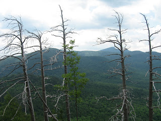
The summit is generally treed with a few outcroppings with terrific views to southwest. The East side of GIANT Mountain was directly in front of us to the south and west. Dix Mountain (and it's slides), Nippletop, Wolf Jaws, Algonquin, and what I think was Haystack were among the mountains we could easily make out. Locating the actual summit was a bit difficult. There is a small mound, surrounded by trees, with a three-rock cairn that we claimed to be the summit. It's a little higher than the surrounding outcroppings, so the kids decided that "this is OUR summit!"
There are a couple trails on the summit, but we didn't take them. Instead, I had the great honor to bump into Pete Fish on the summit. He is a retired NYS forest ranger whom I got to know while hiking the High Peaks in the 90's. He's still out hiking, and as usual, and is full of insightful information about the High Peaks that he was sharing with the people on the summit. After talking for awhile, he took our picture for us, and then scampered down the trail.
The return trip was started after a major wind gust struck - a not so subtle reminder that thunderstorms were on the way. We started down, and had a pretty uneventful hike, arriving back at the trail head around 1:30pm. Once there, we talked about the hike up Cascade that we are planning tomorrow. I also pointed to the fire tower atop Hurricane Mountain. Of course, the tykes want to climb Hurricane tomorrow as well. "Sure we can" I replied, "as soon as we finish Cascade, we'll go right to Hurricane, if there's time, and you want to do it." Hee hee! I suspect that Cascade will be plenty for them. :-)
This trip wasn't over yet... It started to rain as soon as we got into the car. Not long afterward... BOOM! ...And the rain fell as sheets of glass against everything. It was a rather impressive storm. ...Am I a bad dad because only 'part' of me is happy we got back to the car in time? :-)
ADDITIONAL INFORMATION:
For Additional Information on Baxter Mountain, click on one of the following links:
- Adirondack Trail Running
- The Best of The Adirondacks
- Baxter Mountain, A Quick Adirondack Hike
- Best Easy Day Hikes - Adirondacks (by Lisa Densmore), Chapter 2 - "Baxter Mountain" - Page 14
STATS SUMMARY:
Date of Summit: 07/06/2011
Team: Mike, Teena, Liz, Nick
Location: Adirondack High Peaks (44.21697,-73.764868)
Summit Elevation: 2,341'
Vertical Ascent: ~668'
Approach: NY 9N, about 2 miles east of Rt 73, ~50 yards east of Hurricane Rd.
Trailhead to Summit: ~1.1 miles
Time to summit: ~40 minutes
Weather: Sunny, and temps in the mid-70's. Slightly breezy. BIG THUNDERSTORM at finish!
Trail Difficulty: Easy and FUN! Another perfect starter hike for young kids.
Pictures: (30 pictures) Click on picture to see a larger version.
 |
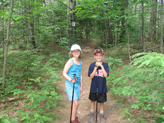
| Lizzard and Turbo are set to start the hike up Baxter Mountain. Can you see the energy radiating from them? |
 |
| The trail started off relatively easy, with dirt and well-maintained steps. |
 |
| Ah yes! Adirondack trail roots! I forgot how crazy the roots get on the trails! |
 |
| The trail was well-maintained. There were countless downed trees along the trail that were cut by a maintenance crew. |
 |
| Follow the blue trail markers! |
 |
| The trail continued to be relatively straight forward. Perfect for young children who are being introduced to the Adirondacks! |
 |
| Uh oh... "MORE ROOTS?!?!?" Hey...! Where did all their energy go? |
 |
| Lizzard hikes the boardwalk. Usually, boardwalks like this exist in areas that are prone to mud and erosion. Luckily for us, it was early July, and everything was very dry. |
 |
| Trail junction! Almost there! The summit was ~0.1 miles from this point. |
 |
| An interesting thing about this trail is that it has many switchbacks. Um... Turbo? SLOW DOWN! :-) |
 |
| Getting a tad steeper! Of course, this isn't a challenge for tykes who climb like billy goats! |
 |
| Lizzard poses at the summit. "That was an easy hike, dad." |
 |
| The alpine foliage at the summit is pretty typical of the summits of the High Peaks. It's very fragile, and is only found at high latitude polar regions. |
 |
| A solitary skeletal tree. Dix Mountain in the far background. ...Just thought this was a COOL picture! |
 |
| "What??? We have to hike all the way DOWN now?" |
 |
| Um... Which way should we go??? We hiked via the Rt 9N route. Maybe we'll try the Beede Road entry point next time? |
 | |
| "Are we near the car yet?" Hee hee... Wait until we hike Cascade tomorrow! |
 |
| "Can I take this rock home with me?" Um..... No. |
 |
| Think hiking with an 8-year old boy is easy? Guess again... Notice the legs... They have one speed. Fast! And they have no fear of getting hurt! |
 |
| On the way down to the car, Turbo jumps on just about anything that will support his weight. Can you take my picture?" This fallen tree was actually very cool looking. |
 |
| "I'm taking *this* rock home with me!" |
 |
| ...And Lizzard was just as hungry. ...Um... ...and apparently thirsty too. :-o |
 |
| TURBO! STOP DRINKING MY BEER!!! |


1 comment:
Just a short comment on the bare trees. Im not sure about your area but in NC we have the same thing and its a result of Acid Rain.
Post a Comment